10 Boynton Beach neighborhoods from Downtown to Hunters Run: ZIP codes, zoned schools and their 2026 state grades, and August 2026 Zillow values.
Last checked Oct. 8, 2026. Sources: the City of Boynton Beach’s neighborhood map layer, its CRA district layer and its comprehensive plan; Palm Beach County’s address points and city limits; the School District of Palm Beach County’s attendance boundaries; the Florida Department of Education’s 2026 school grades; Zillow Research; the Census Bureau; and OpenStreetMap.
Boynton Beach is a city of 81,435 people in southeast Palm Beach County, according to the Census Bureau’s 2020-2024 American Community Survey. Its city limits cover about 16.6 square miles, from the Intracoastal Waterway on the east to west of Congress Avenue and, in the north, out toward Lawrence Road. The beach itself is across the water, at the city’s Oceanfront Park.
I-95 splits the city. East of it are Federal Highway, Seacrest Boulevard, downtown on Ocean Avenue and the city’s historic sites. West of it, Congress Avenue is the main north-south road, lined with shopping centers and walled residential communities. Boynton Beach Boulevard, Woolbright Road, Gateway Boulevard and Hypoluxo Road cross the city east to west.
Three things to know before you look at a listing:
- Three main ZIP codes. Of about 42,700 street addresses inside the city limits in Palm Beach County’s address data, 43% are in 33435, the east side; 34% in 33426, the middle; and 23% in 33436, the west. The county’s data also lists about 52,700 addresses with a Boynton Beach mailing city in unincorporated Palm Beach County, including all 22,500 in ZIP code 33437. A Boynton Beach address is not proof of a city address.
- Three high school zones. In the school district’s attendance boundaries, 77% of addresses in the city are zoned for Boynton Beach Community High, 13% for Atlantic High in Delray Beach and 9% for Santaluces Community High in Lantana. School zones do not follow city limits; check one address with the district’s Find My School map.
- One public school district. Every public school is run by the School District of Palm Beach County. More in our schools guide.
The areas at a glance
Home values are the Zillow Home Value Index for the area’s ZIP code in August 2026, a modeled typical value for the middle third of homes, not a sale price, and a figure for the whole ZIP code, not just the neighborhood. High school grades are Florida’s 2026 grades.
| Area | ZIP | Zoned high school | ZIP home value, Aug. 2026 | Guide |
|---|---|---|---|---|
| Downtown | 33435 | Boynton Beach Community (B) | $308,335 | Downtown |
| Heart of Boynton | 33435 | Boynton Beach Community (B) | $308,335 | Heart of Boynton |
| Rolling Green | 33435 | Boynton Beach Community (B) | $308,335 | Rolling Green |
| Seacrest Estates | 33435 | Boynton Beach Community (B) | $308,335 | Seacrest Estates |
| Chapel Hill | 33435 | Boynton Beach Community (B) | $308,335 | Chapel Hill |
| Leisureville | 33426 | Boynton Beach Community (B) | $336,945 | Leisureville |
| Golfview Harbor | 33426 | Atlantic (C) | $336,945 | Golfview Harbor |
| Hunters Run | 33436 | Atlantic (C) | $410,837 | Hunters Run |
| Boynton Lakes | 33426 | Santaluces Community (B) | $336,945 | Boynton Lakes |
| The Meadows | 33436 | Santaluces Community (B) | $410,837 | The Meadows |
On the year to August 2026, the index rose 1.7% in 33435, 0.5% in 33426 and 0.6% in 33436. The citywide Boynton Beach figure was $403,510, down 0.3%. More in our home prices guide.
Map of the areas
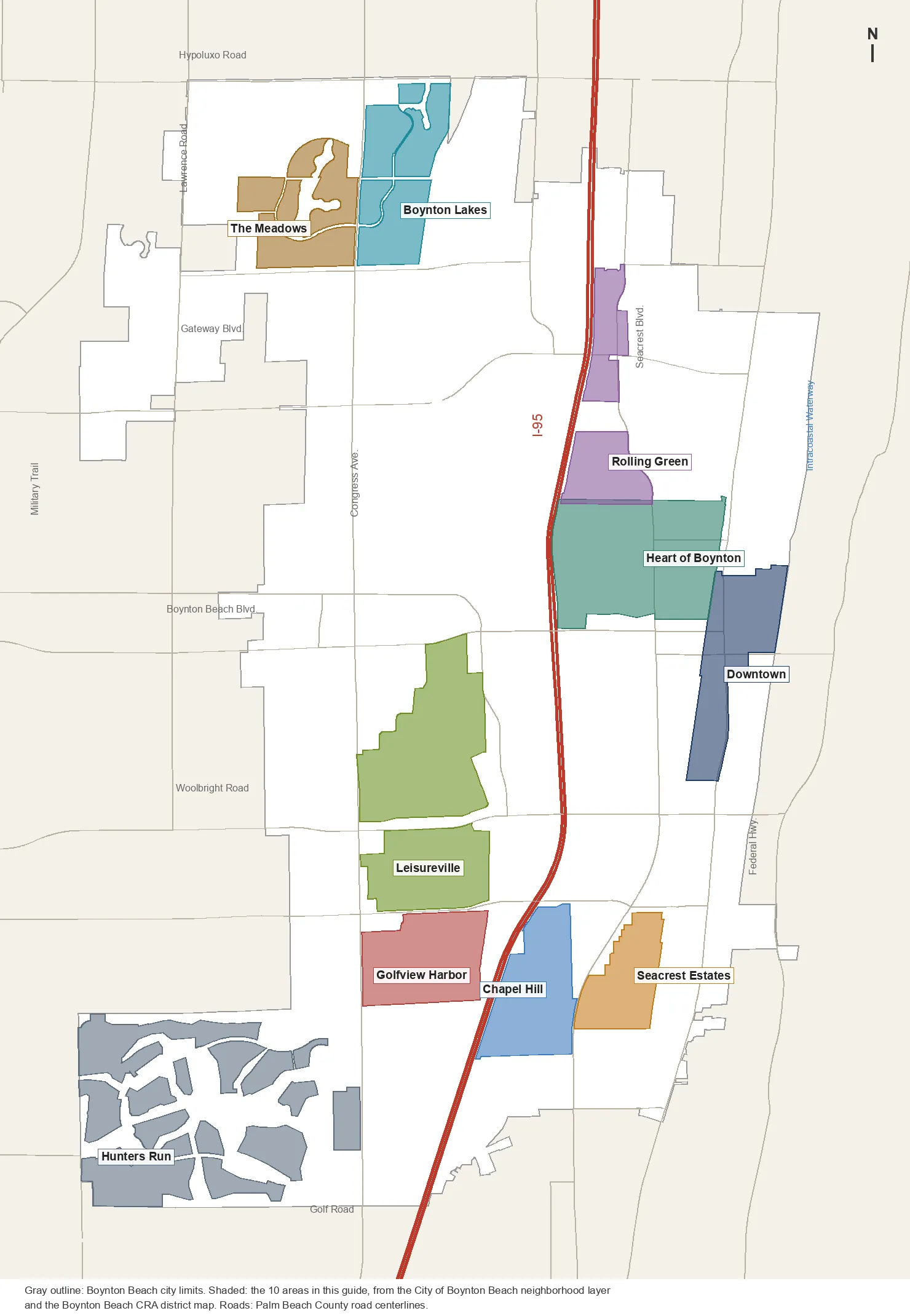
Map by Boynton Beach Daily. Neighborhood outlines are from the City of Boynton Beach’s neighborhood layer and CRA district layer; city limits and roads from Palm Beach County.
The areas
Downtown. The Community Redevelopment Agency’s Downtown district, about 190 acres along Federal Highway and Ocean Avenue, with City Hall, the library, the marina and mostly condominium homes.
Heart of Boynton. The CRA district between I-95 and Federal Highway north of Boynton Beach Boulevard, about 364 acres, crossed by Seacrest Boulevard and Martin Luther King Jr. Boulevard, with six city parks inside it.
Rolling Green. Two neighborhoods on the city’s map, Rolling Green and North Rolling Green, between I-95 and Seacrest Boulevard around Gateway Boulevard, less than a mile from exit 59.
Seacrest Estates. About 126 acres east of Seacrest Boulevard in the south of the city, mostly single-family homes, with Betty Thomas Park inside it.
Chapel Hill. About 189 acres between I-95 and Seacrest Boulevard south of Southwest 23rd Avenue, almost all single-family homes, near the county’s Caloosa Park.
Leisureville. Palm Beach Leisureville and Boynton Beach Leisureville, about 469 acres east of Congress Avenue between Boynton Beach Boulevard and Southwest 23rd Avenue, the largest area in this guide by street addresses.
Golfview Harbor. About 191 acres between Congress Avenue and I-95 south of Southwest 23rd Avenue, zoned for Atlantic High.
Hunters Run. The golf community west of Congress Avenue in the city’s southwest corner, about 474 acres of homes in 21 sections on the city’s map.
Boynton Lakes. Boynton Lakes and Boynton Lakes North, east of Congress Avenue between Miner Road and Hypoluxo Road, with Boynton Lakes Park.
The Meadows. Nine sections west of Congress Avenue north of Miner Road, the only area in this guide zoned for Tradewinds Middle, an A school.
Downtown also has its own visitor guide: downtown Boynton Beach.
How we built this
We named only areas a public source places on a map. The sources were:
- The City of Boynton Beach’s neighborhood layer (“Neighborhoods 2021 Update”), which draws 190 polygons with 171 names inside the city and records an association name for many of them. We chose eight of the largest residential areas, spread across the city, and joined pieces that share a name (Boynton Lakes and Boynton Lakes North, for example). Each area page says which pieces it includes.
- The city’s CRA district layer, which draws seven districts of the Community Redevelopment Area. Downtown and the Heart of Boynton are two of them.
- The city’s comprehensive plan. Its Future Land Use Element defines the Downtown TOD District around Ocean Avenue and the Florida East Coast rail corridor; it does not divide the rest of the city into named areas.
- OpenStreetMap, whose place names inside the city include only Chapel Hill.
- Palm Beach County’s address points, about 42,700 inside the city, used for ZIP code and home counts, matched on Oct. 8 to the school district’s attendance boundaries (elementary zones for 2026-27; middle and high zones as the district labels them, for 2025-26). Find My School is the final word for any address.
- Distances measured on the OpenStreetMap road network with the OSRM routing engine; bus routes from Palm Tran’s route pages; parks from Palm Beach County’s municipal parks layer and the city; stores from OpenStreetMap, © OpenStreetMap contributors.
We do not rank areas. Every figure on these pages is from a named public source; if you see one that is out of date, tell us on our corrections page.
Related: schools, home prices, property taxes, getting around and Boynton Beach vs. Lantana vs. Delray Beach vs. Lake Worth Beach.
Frequently asked questions
What are the neighborhoods in Boynton Beach, Florida?
The City of Boynton Beach’s neighborhood map names 171 neighborhoods inside the city. Our guide covers 10 of them across the city: Downtown, the Heart of Boynton, Rolling Green, Seacrest Estates, Chapel Hill, Leisureville, Golfview Harbor, Hunters Run, Boynton Lakes and The Meadows.
What ZIP codes are in Boynton Beach?
Three main ones. Of about 42,700 street addresses inside the city limits in Palm Beach County’s address data, 43% are in 33435, 34% in 33426 and 23% in 33436. None of the 22,500 addresses in 33437 is inside the city.
What high school is Boynton Beach zoned for?
It depends on the address. In the school district’s attendance boundaries, 77% of addresses in the city are zoned for Boynton Beach Community High, 13% for Atlantic High in Delray Beach and 9% for Santaluces Community High in Lantana.
Which I-95 exits serve Boynton Beach?
Four: exit 56, Woolbright Road; exit 57, Boynton Beach Boulevard; exit 59, Gateway Boulevard; and exit 60, Hypoluxo Road. Florida’s Turnpike exit 86, Boynton Beach Boulevard, is west of the city.
Is a Boynton Beach mailing address in the city of Boynton Beach?
Not always. Palm Beach County’s address data lists about 52,700 addresses with a Boynton Beach mailing city that are in unincorporated Palm Beach County, more than inside the city itself. The Property Appraiser’s property search shows which city, if any, a parcel is in.
Have your say