The coastal flood advisory ended Tuesday evening. Isolated minor tidal flooding and a high rip current risk last through Wednesday evening. Next king tides: Nov. 24-27.
The coastal flood advisory for coastal Boynton Beach ended at 7 p.m. Tuesday. The National Weather Service in Miami still expects “isolated minor coastal flooding” within 1.5 to 2 hours of high tide through Wednesday evening. The high rip current risk also runs through Wednesday evening. The next king tides are expected Nov. 24-27.
Updated Nov. 4: The advisory was not extended again and ended at 7 p.m. Tuesday. At 3:23 a.m. Wednesday the weather service issued a coastal flood statement and rip current statement for coastal Palm Beach County through Wednesday evening, warning of “some water on low lying roads and property.” On Tuesday the Deerfield Island Park gauge peaked at 1.65 feet at 3:12 a.m., minor flood stage. The Lake Worth Pier gauge peaked at 1.21 feet at 3:30 p.m., below minor flood stage. Monday evening’s flash flood warning was extended to 8:45 p.m.; see our flood report.
Updated Nov. 2, evening: The weather service’s 3:20 p.m. Monday update extended the coastal flood advisory and the high rip current risk to 7 p.m. Tuesday. The high surf advisory ended at 7 a.m. Monday. On Monday the Lake Worth Pier gauge peaked at 1.47 feet at 2:18 p.m., minor flood stage, and the Deerfield Island Park gauge at 1.74 feet at 2:42 p.m., moderate. Tuesday’s high tides are 4:24 a.m. and 4:56 p.m. At 5:27 p.m. the weather service issued a flash flood warning for eastern Palm Beach County until 7:30 p.m.
Updated Nov. 1, evening: The weather service’s 1:20 p.m. Sunday update extended the coastal flood advisory, due to end at 7 p.m. Sunday, to 7 p.m. Monday. It kept the high surf advisory to 7 a.m. Monday, with breakers of 5 to 7 feet, and extended the high rip current risk through Tuesday evening. At 12:49 p.m. it issued a flood watch for heavy rain until 3 p.m. Monday. On Sunday the Lake Worth Pier gauge peaked at 1.63 feet at 12:48 p.m., minor flood stage, and the Deerfield Island Park gauge at 1.88 feet at 1:54 p.m., moderate. Monday’s high tides are 3:13 a.m. and 3:55 p.m.
Updated Oct. 31, evening: The weather service’s 4:59 p.m. Saturday update extended the coastal flood advisory, which was due to end at 8 p.m. Saturday, to 7 p.m. Sunday. It moved the end of the high surf advisory and the rip current statement from Sunday evening to 7 a.m. Monday, and lowered the expected breakers from 6 to 10 feet to 5 to 8 feet. The nearest tide gauges have stayed at moderate flood stage, a little lower each day. Sunday’s high tides are 2:04 a.m. and 2:51 p.m.
Updated Oct. 30, afternoon: The weather service’s 2:47 p.m. Friday update added the high surf advisory for Saturday and Sunday. It warned of “dangerous swimming and surfing conditions and localized beach erosion.”
Updated Oct. 30: The advisory was due to end at 8 p.m. Thursday and has been extended to 8 p.m. Saturday. On Thursday the nearest tide gauges peaked at moderate flood stage, below the major readings of Tuesday and Wednesday. Friday’s high tides are 12:59 a.m. and 1:49 p.m.; Saturday’s are 1:58 a.m. and 2:48 p.m.
Updated Oct. 28, evening: The nearest tide gauges reached major flood stage for a second morning on Wednesday. The warning and the high surf advisory end at 8 p.m. Wednesday. A coastal flood advisory and the high rip current risk run until 8 p.m. Thursday. Thursday’s high tides are 12:05 a.m. and 12:53 p.m.
Updated Oct. 28, morning: The watch became a warning Tuesday, and the nearest tide gauges reached major flood stage Tuesday morning. The warning, the high surf advisory and the high rip current risk all run until 8 p.m. Wednesday. The original Oct. 25 report on the watch is further down this page.
What is in effect
The weather service’s alerts for coastal Palm Beach County, as of 3:23 a.m. Wednesday, list two:
| Alert | What the weather service expects | When |
|---|---|---|
| Coastal flood statement | Isolated minor coastal flooding near high tide | Through Wednesday evening |
| High rip current risk | Dangerous rip currents | Through Wednesday evening |
A statement is a step below an advisory. The coastal flood advisory ended at 7 p.m. Tuesday, the high surf advisory at 7 a.m. Monday and the flood watch at 11 p.m. Monday. “Do not drive through flooded roadways,” the weather service said.
What the tide gauges showed Friday to Sunday
The readings fell a little each day. On Sunday the Lake Worth Pier gauge dropped to minor flood stage. These are the day’s highest readings on NOAA’s National Water Prediction Service:
| Gauge | Friday, Oct. 30 | Saturday, Oct. 31 | Sunday, Nov. 1 |
|---|---|---|---|
| Lake Worth Pier, about six miles north | 2.16 feet at noon | 1.81 feet at 12:48 p.m. | 1.63 feet at 12:48 p.m. |
| Intracoastal Waterway at Deerfield Island Park, about 15 miles south | 2.25 feet at 12:48 p.m. | 1.93 feet at 2 p.m. | 1.88 feet at 1:54 p.m. |
Sunday’s readings are as of Sunday evening.
What the tide gauges showed Thursday
Both gauges peaked at moderate flood stage on Thursday morning, about 0.3 feet lower than Wednesday. Moderate flood stage is 1.7 feet above the average higher high tide; major is 2.5 feet.
- Lake Worth Pier, about six miles north: 2.31 feet at 11:06 a.m. (gauge page).
- Intracoastal Waterway at Deerfield Island Park, about 15 miles south: 2.39 feet at 11:54 a.m. (gauge page).
Around midnight Thursday into Friday, Lake Worth Pier read 1.54 feet and Deerfield Island Park 1.87 feet.
What the tide gauges showed Wednesday
Both gauges topped major flood stage again on Wednesday morning, a little lower than Tuesday. These are the day’s highest readings on NOAA’s National Water Prediction Service:
- Lake Worth Pier, about six miles north: 2.67 feet at 10:12 a.m.
- Intracoastal Waterway at Deerfield Island Park, about 15 miles south: 2.71 feet at 11:06 a.m. (gauge page).
By late Wednesday afternoon, at low tide, both were back below the average higher high tide.
What the tide gauges showed Tuesday
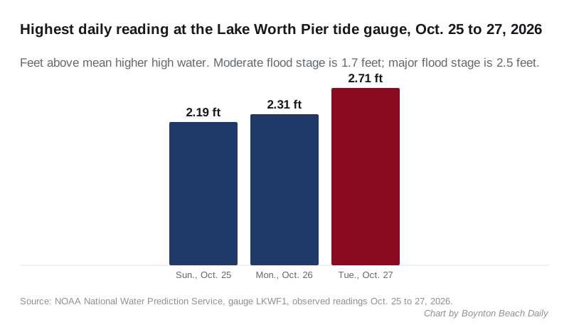
Three NOAA gauges near Boynton Beach crossed major flood stage on Tuesday morning. Major flood stage at each is 2.5 feet above the average higher high tide. Moderate is 1.7 feet. These are the highest readings of each day on NOAA’s National Water Prediction Service:
| Gauge | Sunday, Oct. 25 | Monday, Oct. 26 | Tuesday, Oct. 27 |
|---|---|---|---|
| Lake Worth Pier, about six miles north | 2.19 feet | 2.31 feet | 2.71 feet at 9:24 a.m. |
| Intracoastal Waterway at Deerfield Island Park, about 15 miles south | 2.40 feet | 2.64 feet | 2.79 feet at 10:18 a.m. |
The Deerfield Island Park gauge peaked about an hour after the Lake Worth Pier. Both rose each morning. At about 10 p.m. Tuesday, both were still at moderate flood stage: 1.91 feet at Lake Worth Pier and 2.22 feet at Deerfield Island Park.
The Deerfield Beach Pier gauge is left out of the table. It logged a single 4.57-foot reading early Tuesday afternoon, far above its neighbors, and has gaps in its record. We could not confirm that reading.
These are the king tides
Palm Beach County lists Oct. 26-29 as this year’s fall king tide dates on its king tides page. The next set is Nov. 24-27. The county notes that king tide flooding “is not guaranteed during these dates.” This week the weather service has also forecast a strong northeast wind and high surf.
When the water is highest
These are NOAA’s predicted high tides at its Boynton Beach station on the Intracoastal Waterway:
| Day | High tide | Height above mean lower low water |
|---|---|---|
| Monday, Nov. 2 | 3:13 a.m. | 2.9 feet |
| Monday, Nov. 2 | 3:55 p.m. | 3 feet |
| Tuesday, Nov. 3 | 4:24 a.m. | 2.9 feet |
| Tuesday, Nov. 3 | 4:56 p.m. | 3 feet |
The times are Eastern Standard Time; daylight saving time ended Sunday.
These are astronomical predictions. The wind and surf can push the water higher than the table shows. On Tuesday the Lake Worth Pier gauge peaked at 9:24 a.m., before the 11:12 a.m. predicted high tide at the Boynton Beach station.
What we could not confirm
Several TV stations reported that the city is handing out sandbags. The city has posted no notice about sandbags, tidal flooding or road closures on its news page or in its alert center as of Friday morning. Its alert center listed no active alerts on Sunday evening. We will add the city’s own details here if it publishes them.
What it means for you
- Monday’s 3:55 p.m. high tide falls inside the advisory. Allow extra time near the Intracoastal and the beach from early afternoon. Heavy rain at high tide could make it worse, the weather service said.
- Do not drive around barricades or through water of unknown depth, the weather service said.
- Protect flood-prone property. The weather service said to “take the necessary actions to protect flood-prone property.” The county’s king tides page advises keeping sandbags on hand.
- Stay out of the ocean if you are not an experienced swimmer, the weather service said. Breakers of 5 to 7 feet are expected until 7 a.m. Monday, and the rip current risk runs through Tuesday evening. Swim only near a lifeguard. At the city’s Oceanfront Park, lifeguards are on duty from 9 a.m. to 5 p.m. every day. The beach conditions line is 561-742-6775.
- If a rip current catches you, relax and float, and do not swim against it. Swim parallel to the shoreline if you can. If you cannot escape, face the shore and call or wave for help.
For storm planning, see hurricane prep in Boynton Beach. For outages, see our power outages page. The beach and the parks are covered in our parks and trails guide.
Earlier: the watch issued Oct. 25
Coastal Boynton Beach faces moderate flooding at high tide and breaking waves of 4 to 13 feet through Monday. A coastal flood watch for “significant coastal flooding” follows from late Sunday night through Tuesday morning.
The National Weather Service in Miami issued the alerts for coastal Palm Beach County at 3:21 p.m. Saturday. Its coastal hazard message lists four at once:
| Alert | What the weather service expects | Until |
|---|---|---|
| Coastal flood advisory | Moderate coastal flooding | 2 a.m. Monday |
| High surf advisory | Breaking waves of 4 to 13 feet in the surf zone | 8 p.m. Monday |
| High rip current risk | Dangerous rip currents | Monday evening |
| Coastal flood watch | Significant coastal flooding possible | 11 a.m. Tuesday |
The watch starts at 2 a.m. Monday, as the advisory ends. A watch means the flooding could happen. The weather service would issue a warning if it becomes likely.
What the weather service says could flood
The message warns that “numerous roads may be closed.” It also says “low lying property including homes, businesses, and some critical infrastructure may be inundated.”
Some shoreline erosion may occur, the weather service said. It expects “dangerous swimming and surfing conditions and localized beach erosion.”
The wind is a big part of this. The local forecast calls for a northeast wind of 10 to 20 mph Sunday, with gusts to 30 mph. Monday and Tuesday bring northeast winds of 16 to 22 mph, with gusts as high as 35 mph. Showers and thunderstorms are likely each day.
No storm is behind it. The National Hurricane Center’s 8 p.m. Saturday outlook said no tropical cyclone is expected to form in the next seven days.
When the water is highest
Tidal flooding peaks around high tide. The morning tides rise a little each day through Tuesday. These are the National Oceanic and Atmospheric Administration’s predicted high tides at its Boynton Beach station on the Intracoastal Waterway:
| Day | High tide | Height above mean lower low water |
|---|---|---|
| Sunday, Oct. 25 | 9:38 a.m. | 3.4 feet |
| Sunday, Oct. 25 | 9:45 p.m. | 3.2 feet |
| Monday, Oct. 26 | 10:24 a.m. | 3.5 feet |
| Monday, Oct. 26 | 10:29 p.m. | 3.2 feet |
| Tuesday, Oct. 27 | 11:12 a.m. | 3.5 feet |
These are astronomical predictions. The wind and surf can push the water higher than the table shows.
What the tide gauges showed Saturday evening
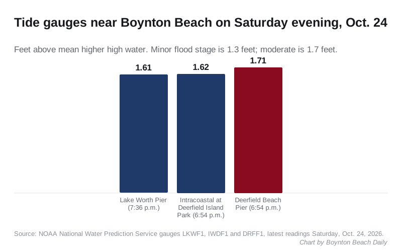
The nearest ocean and Intracoastal gauges were already above flood stage on Saturday evening, before the 9:01 p.m. high tide. One reached moderate flood stage. These are the latest readings on NOAA’s National Water Prediction Service gauge pages, in feet above the average higher high tide:
- Deerfield Beach Pier, about 15 miles south: 1.71 feet at 6:54 p.m., moderate flood stage.
- Intracoastal Waterway at Deerfield Island Park, about 15 miles south: 1.62 feet at 6:54 p.m., minor flood stage (gauge page).
- Lake Worth Pier, about six miles north: 1.61 feet at 7:36 p.m., minor flood stage (gauge page).
At all three gauges, minor flood stage is 1.3 feet and moderate is 1.7 feet. On Oct. 9, the last time we reported on high-tide flooding, no reading reached moderate stage.
Have your say